Mount Sutro: An Electronic Periodical

216042024
1338Hours EDT

The Reason We Are Out Here

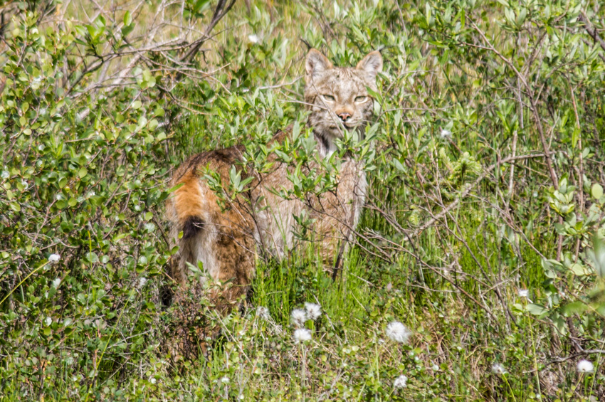
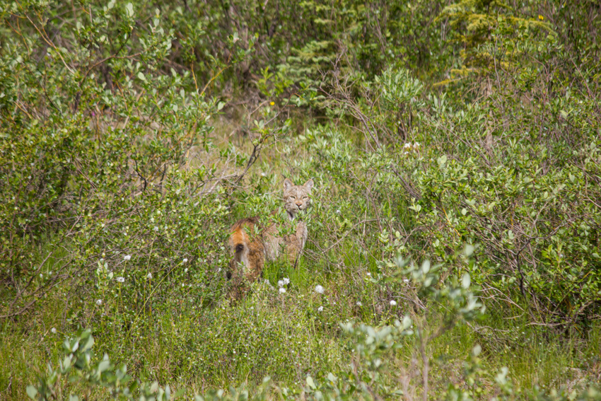
A Canada lynx (Lynx canadensis) stops and looks at us from the brush alongside the Dalton Highway (AK 11) shortly after crossing the road southwest of Sukakpak Mountain.

MP 202.4 James W. Dalton Highway, Yukon-Koyukuk, Alaska: 24 June 2017

part of the Alaska 2017: Wiseman to Prudhoe Bay album


It all happened so quickly, taking about one minute total.

We had left the excellently quaint village of Wiseman about forty-five minutes earlier to continue our journey to Prudhoe Bay northbound on the James W. Dalton Highway. This section of the road was paved and in relatively good condition, but I still kept my speed down because we were enjoying the drive, scenery and were always watching for animals. Shortly after passing Milepost 202 and coming over a small hill, an animal approached the roadway on the right side and then swiftly jogged across.

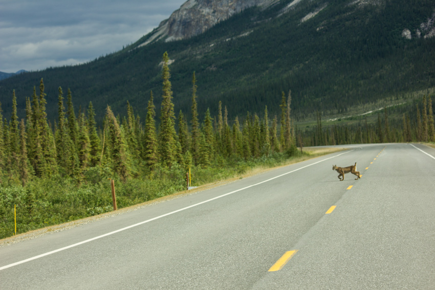
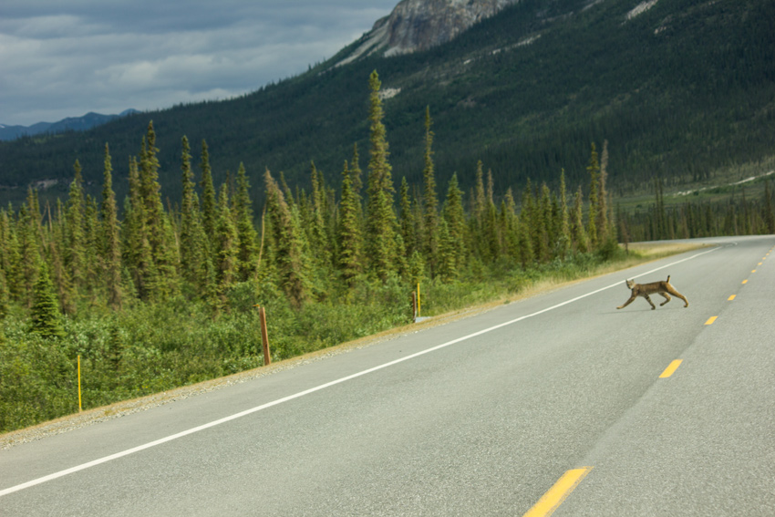
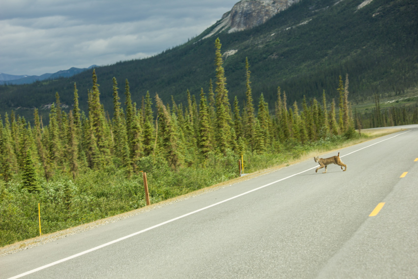
I immediately started slowing down and raised my camera to fire off several frames from the hip, looking not at my camera but focusing on driving safely. Mom was the one to guess what we had come across and the notion was rather exciting. I brought the car to a stop where the animal had left the roadway and entered the brush. Sure enough, darting away from us was a Canada lynx.

As they are known to be nocturnal, elusive and an avoider of human contact, it was awesome to see a lynx in the wilderness, let alone just before noon. Despite the name, Canada lynx inhabit forests in Canada and Alaska with additional populations in the lower forty-eight — where it is considered a threatened species — in Idaho, Montana, Oregon, Washington and Wyoming. Twice the size of a domestic cat, the Canada lynx sports hair tufts atop its ears, long lower cheek ruffles and a short, black-tipped tail.

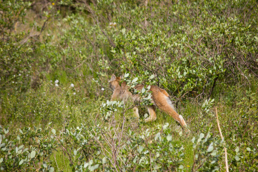
Fortunately, the lynx stopped not too far away to check us out for a moment, staring with typical feline intensity.

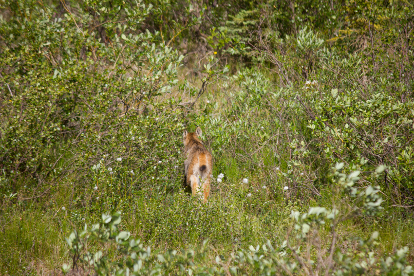
Just as the lynx decided to retreat into the thicker forest and out of visual range, my attention was drawn to a sound from above. Circling overhead and screeching loudly was a northern harrier, a hawk that breeds in Alaska and Northern Canada.

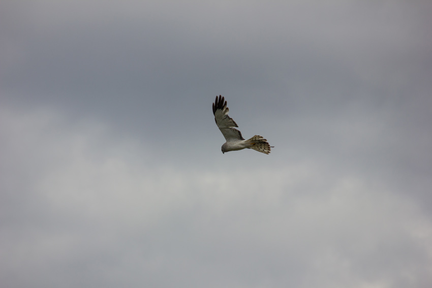
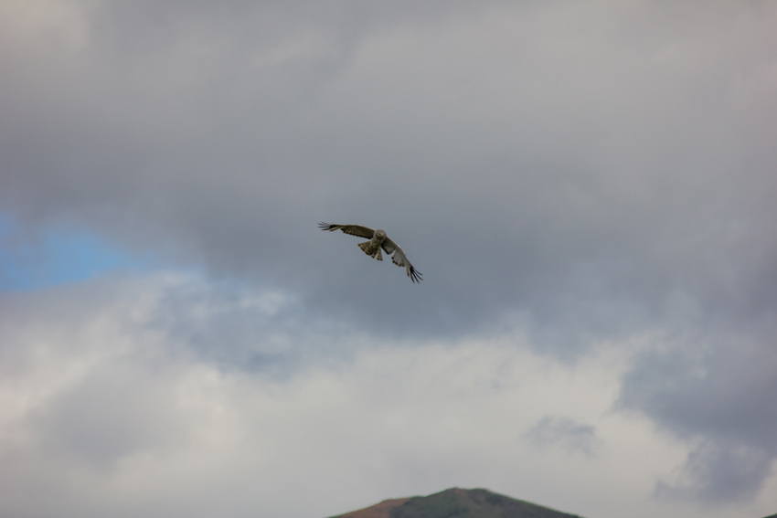
Although it seemed quite upset by the big cat's presence, the northern harrier probably did not have much to worry about. Canada lynx in these northern regions feed almost exclusively on snowshoe hare, large rabbits that are white in the winter and then brown in the summer. Cyclical patterns in hare populations affect the lynx as well; as the number of hares increase and decrease, so does the number of lynx. From what we saw, the local hare population was on the rise.

Even though we could no longer see the lynx, we watched the northern harrier continue to circle and squawk in the sky, each circle moving further from the road as the cat continued away. We soon left as well, but were especially pleased with our good fortune. Two days later on the drive back to Fairbanks, we again stopped at the Arctic Interagency Visitor Center in Coldfoot and told the rangers there of our various animal sightings in the area and up in Prudhoe Bay.

I saw so many kinds of animals during my Alaska adventure, several of them rather close, but the Canada lynx was certainly a rarer find and something I am fortunate to have seen.

The Passageway Underneath The Railroad

Facing south in the pedestrian tunnel (2000) built under Whittier Yard by the Alaska Railroad Corporation.

Near 1/4 West Camp Road, Whittier, Alaska: 21 June 2017

part of the Alaska 2017: Whittier album


A small community of about 250 residents, the City of Whittier (incorporated 1969) was originally built by the United States Army as Camp Sullivan, an important deepwater port supporting operations during World War II. The railroad was extended to Whittier on Friday, 23 April 1943 upon completion of the Anton Anderson Memorial Tunnel — 2.52 miles through Maynard Mountain and a journey I will later document — allowing Camp Sullivan to become "primary debarkation point for cargo, troops and dependents of the Alaska Command."

During the Whittier Access Project (1998–2000), the tunnel was upgraded to "transform the existing railroad tunnel into a one-lane, combination highway and railway tunnel that allows cars and trains to take turns traveling through." The Anton Anderson is likely what comes to mind when thinking about Whittier tunnels, but there is another, smaller-scale tunnel there that I also checked out during my visit.

Providing safe passage underneath the large Whittier Yard rail facility since June 2000, the Alaska Railroad Corporation pedestrian tunnel connects the northern waterfront area to the southern downtown area. Approximately 512 feet long, the pedestrian tunnel provides an alternative to walking to the Whittier Street grade crossing, which is blocked at times by trains, or dangerously crossing the expansive rail yard itself. As nearly all of Whittier's residents live in the Hodge Building (1957), now Begich Towers, the tunnel provides a safer and more direct route to the marina for those on foot.

Having learned about the pedestrian tunnel in our copy of The Milepost, I was eager to take a closer look as we explored the marina area. Each side of the tunnel is marked by a nice sign featuring a cool logo reminiscent of the tunnel's illuminated and ribbed interior. We approached from the northern side, passing the sign on a sidewalk that leads to an area covered by a metal roof. Once inside, the tunnel takes two sharp turns and then opens into a straight passageway underneath the railroad.

The Containers Down In Cargo Bay Three

Plastic industrial containers called overpack drums and metal barrels behind a chain link fence at North Slope Borough's Sanitation Services Shop III and thermal oxidation plant.

3490 Stevenson Street, Utqiaġvik, Alaska: 27 June 2017

part of the Alaska 2017: Utqiaġvik album


"Wait, can we turn around for a second?"

Mom and I were exploring Utqiaġvik, stopping and checking things out along the way, so my request to double back was not unusual. I thought we had just past something that, while not unusual at industrial sites, was an object that I had only ever seen in the twenty-fourth century. Naturally, she asked why we were turning around. Not sure in the moment how to reply succinctly, I stalled on this question until I could confirm my suspicions.

As we pulled up and they came into view outside my open window, I chuckled to myself that it was in Utqiaġvik, at the top of the world of all places, where I would first run across industrial containers called overpack drums of the same type as those frequently seen in Star Trek: The Next Generation (1987–1994).

I took two photographs and then we continued exploring, while I explained why these containers — stacked in the yard of North Slope Borough's Sanitation Services Shop — were noteworthy. The yellow overpack drums, made of polyethylene and featuring a threaded lid, made their Starfleet debut in "Disaster", the fifth episode of The Next Generation's fifth season.

I am unable to establish what specific manufacturer's overpack drums appeared aboard the starship Enterprise, but several companies offer very similar products today. Of those present in Utqiaġvik, three appear to be of the same make, model and vintage as the props. Looking at the photograph atop this article and thinking of a spreadsheet, yellow drums A1, B2 and D2 match the subtle design features of those sourced for the show in 1991.

"Disaster" does a good job of showing off the then new props. In a cargo bay where Chief Engineer Lieutenant Commander Geordi La Forge (LeVar Burton) and Chief Medical Officer Doctor Beverly Crusher (Gates McFadden) are trapped, the containers and their volatile contents are a plot point. Not just set dressing for the cargo bay, the two actors also get physical with the overpack drums.

La Forge and Crusher push an overpack drum across the cargo bay floor
Paramount Pictures

There are several shots of overpack drums clustered and stacked, one contemporary selling point of these containers.

La Forge watches as the cargo bay door opens with stacks of overpack drums behind
Paramount Pictures

As a bonus, the episode also shows versions of the overpack drums (plus other blue cargo drums) in miniature as they are jettisoned into space. Two of those miniatures went home with writer Ronald D. Moore; they were later auctioned.

Miniature overpack drums and other barrels are jettisonned from the cargo bay into space
Paramount Pictures

Yellow overpack drums with their red and white graphics continued to be used throughout the run of Star Trek: The Next Generation, often appearing in the background but sometimes featured more prominently. One good example of the latter is the sixth episode of the sixth season — "True Q" — when the containers are given blue and white graphics to depict their use as medical cargo.

Medical-use overpack drums on the shuttlebay floor in front of shuttlecraft Fermi
Paramount Pictures

Following the end of the television show, the containers went on to reprise their roles, as it were, in the first motion picture featuring Picard and crew, Star Trek Generations (1994) seen at villain Tolian Soran's launcher on Veridian III and of course aboard Enterprise. The overpack drums were later repainted mostly black for use in Star Trek: Voyager (1995–2001) and Star Trek: Enterprise (2001–2005).

Counselor Deanna Troi next to an overpack drum aboard USS Enterprise
Paramount Pictures

Okay, so maybe it is a little silly, but I find great enjoyment in appreciating the little things in life. Considering the dramatic flair of randomly encountering these overpack drums after twenty-five years, eight months and seven days in a place few people ever visit, it was obviously meant to be.

The Gateway To The Arctic

The Utqiaġvik bowhead whale (Balaena mysticetus) jaw bone arch along with other whale bones and the wooden frame of an umiak, an Iñupiat seal skin whaling boat, along the shore of the icy Chukchi Sea, Arctic Ocean.

3220 Brower Street, Utqiaġvik, Alaska: 28 June 2017

part of the Alaska 2017: Utqiaġvik album


"Why are you going to Barrow," asked the oil field worker seated next to me.

We were on a flight from Anchorage to Prudhoe Bay (Deadhorse), the second segment of my journey from Fairbanks to Utqiaġvik, the northernmost United States city and eleventh northernmost public community in the world. Previously called Barrow, a narrow election (381 yea to 375 nay) on Tuesday, 04 October 2016 resulted in the name change to Utqiaġvik, taking effect on Thursday, 01 December 2016.

"Because I have never been there," I replied. "I came all the way to Alaska, why not go to the top of the world?"

My visit to Utqiaġvik (pronounced oot–kay-ahg–vik) would be a brief one, clocking in at about twenty-four hours. During that time, I wanted to see and learn as much as possible about this remote community of 4,212 (2010). The Iñupiat, an indigenous Inuit people, have lived in this area since around 500 AD and Alaska Natives account for 61.2 percent of Utqiaġvik's population. While some modern advances have changed the society, the native traditions continue to be observed in many ways.

One of those traditions is the whale hunt. Part of the subsistence way of living that is common in the region, the Iñupiat have hunted whales in the waters just offshore for centuries, considering it necessary for survival and a significant spiritual experience. Beyond it being a source of food, the Iñupiat believe in using every part of the whale, the bones often fashioned into tools, personal items, art and jewelry. The whale, like all animals hunted by the Iñupiat, are respected and considered a gift to the village benefiting from their sacrifice. Today, a handful of native villages are still legally permitted a limited number of strikes each season.

Bowhead whale artifacts can be found throughout town, but the most well-known is probably the whale bone arch. Located on the shore of the icy Chukchi Sea, the whale bone arch consists of two jaw bones planted vertically in the ground, forming a wishbone-style monument and gateway to the Arctic Ocean. Sitting nearby are a number of other whale bones, a bowhead skull and the wooden frame of an umiak, an Iñupiat seal skin whaling boat.

Although I could not find any historical details about the arch, an adjacent building has a documented past. The "oldest wood-framed building standing along Alaska's Arctic coast," the Point Barrow Refuge Station (1889) was built to serve as a manned sanctuary for shipwrecked whalers. Following the frequent loss of life and vessels in the Chukchi and Beaufort Sea, whalers from Massachusetts and California petitioned Congress in 1888 for a series of refuge stations. This was the only one built.

A thirty-foot by forty-eight-foot structure constructed to bunk fifty men, the Point Barrow Refuge Station was underutilized for the next seven years due to the lack of shipwrecks. It closed in 1896, due in part to the low demand as well as the station's corrupt superintendent engaging in "shady business dealings." The station was subsequently purchased by the Pacific Steam Whaling Company, which in turn rented it to naturalist Edward Avery McIlhenny. While he was in residence for the winter of 1897, McIlhenny found himself helping one-hundred men, victims of an incident involving eight ships, shelter there for eleven months.

The building was next sold in 1898 to the Cape Smythe Whaling and Trading Company. Its manager, Charles Brower, performed a number of modifications to the building including raising the roof and adding a cross gable at the front. Brower was also responsible for enlarging three windows on the northwest side and building additions to the rear and southwest front of the structure. More recently, the space was home to Brower's Cafe, operated by relatives of Charles, but that restaurant has since gone out of business. The building seemed vacant during my visit to the whale bone arch.

Even though I had already waded into the Arctic Ocean in Prudhoe Bay — an occasion that will no doubt be memorialized here at some point — the temptation to again feel those icy waters was too great. I just touched it with my hands this time, having previously had the experience of stepping barefoot into the frigid shallows, and again concluded that the water was indeed cold.

Standing on the dark, gravelly shoreline, there was a crisp breeze coming off the Chukchi Sea. It was fresh and invigorating but damn cold. Still, I took a few minutes to stand there and enjoy this unique beach before returning to the car to continue our exploration of Utqiaġvik.