


[ click here for the current orlando radar ]
Here are some assorted links of news, pictures and general recovery information.
» PowerPoint Slideshow of Damage Photos (2.5 MB; author unknown)
» Orlando Sentinel Reader's Photos
» FEMA Impersonators Reportedly Targeting Storm Victims
» Power outage updates
» Before starting cleanup
» County reports
» Lynx information
» Important phone numbers
» Best way to help
» What to watch out for
» Red Cross safety information
» Dealing with shock
» What's safe to eat
» Federal Emergency Management Agency
» Help with Insurance Claims or Problems
» County by County Comfort Station Locations
» Volunteer Florida
» Hurricane Financial Assistance for Floridians
» American Red Cross Chapters of Florida
» County Emergency Management Contacts
» Emergency Shelters
» Florida Disaster Assistance
» Report Insurance Fraud
» Orlando Utilities Commission
» Florida Power and Light
» Progress Energy
» Kissimmee Utility Authority
Wednesday, 18 August 2004, 1240
I never thought I would be so excited about it, but I got fuel for my car today! I spent quite a bit of time yesterday looking for a gas station that actually had gasoline and walked away with nothing. Thanks to Costco at 741 Orange Avenue in Altamonte Springs for allowing non-members like me to purchase their fuel. I would also like to point out Real Radio 104.1 FM (also nationwide on XM 152) has been operating in relief and information mode since Charley hit, turning its talk radio shows into the best information source in Central Florida, especially for those without power, television or internet. Their on-air personalities and staff have been collecting water, ice, food and other essentials from generous citizens and local businesses such as Darden Restaurants (proprietors of The Olive Garden, Red Lobster, Smokey Bones, Bahama Breeze and Seasons 52) and Lombardi's Seafood and personally driving around town passing out these items to those in need.
Monday, 16 August 2004, 1401
I just returned from the Arby's restaurant closest to work and waited forty-five (45) minutes in line to order and get my food. The line was out the door and filled with public service employees and people just happy to be in the air conditioning. The cashier at Arby's said since they had little damage and have been able to operate normally over the past few days, they have been making $20,000 in sales daily!
This location is right across the street from the still-closed Orlando Executive Airport (ORL) on East Colonial Drive (State Road 50). Travelling further east down Colonial there are countless businesses with moderate to severe damage to their buildings, awnings and signage. Only one or two billboards have not fully collapsed, in some cases into car lots filled with new and used cars or buildings themselves. There are still over 500 traffic signals inoperative in the area, many of which are in this eastern part of town where there is a lot of severe damage.
Because of the traffic situation this creates on one of the main thoroughfares in Central Florida, the East-West Expressway (State Road 408) that runs parallel to Colonial Drive has suspended toll operations until further notice.
Many people here at the office still do not have electrical power or other essential services such as water, gas or telephone. Cellular service is better, but still hit-and-miss in locations where damage disabled cellular towers and repeater equipment. Costco gas stations, normally available only to paid members, have opened their pumps to all customers to help alleviate the problem with gas shortages.
Selected photographs and articles:
» North Captiva Island Split In Two
» Lynx Bus Service Restored
» Central Florida Damage Photos
» Orange County Begins Emergency Food Distribution
Monday, 16 August 2004, 1225
Tropical Storm Earl has degenerated into an open tropical wave travelling west-northwest through the Caribbean. It will pose no threat as long as it does not regenerate into an organized tropical depression.
It is very hard to find gas stations with fuel available in Orlando at this time. The last word I heard was that locations in Clermont have fuel, but as word spreads of this, they are sure to run out soon. If you are running low on gasoline, it is advisable to locate the closest available source of fuel and fill your vehicle.
Monday, 16 August 2004, 0837
This morning I am back at the office, where the damage I previously reported seemed to be contained to outside structures. Half of the buildings' environmental controls are inoperative, but that seems to be the only issue as so far. I just heard where the awning and other bits of our building ended up: behind the building embedded in a semi-tracker trailer truck.
Driving through Orlando this morning showed that although many traffic signals have been repaired or replaced, downed power lines, trees and other damage remains. Throughout the area, there are still many people and businesses without electrical power, water, telephone and other services. The major power companies are all estimating repairs should be complete no later than Sunday, 22 August 2004. Area schools are also remaining closed until Wednesday. Public transportation services have resumed although I did not see any buses during my morning commute. The Florida Department of Transportation traffic monitoring system is offline so traffic reports normally available by calling 511 or on the over-head display panels is information being gathered manually by Florida Highway Patrol officers.
Government services are partially open, but many of their resources have been redirected to helping those without essential services and providing general information and support to all residents. Ice, water and non-perishable food products are available at various police and fire stations in town. We are also experiencing a fuel shortage so many stations are open to sell food and convenience store products, but have no gas to sell. It is unclear when shipments of gasoline will resume, but it is likely to be a few days before most gas stations are fully operational.
I spent the balance of my weekend helping to clean up the house and yard of all debris and the large limbs that broke away from my oak trees. I went Saturday evening to my favourite drinking establishment, Saint Andrews Pub, a British tavern in Altamonte Springs, Florida and last night to Tees and Cues pool hall because my normal place Clicks is closed as a result of a gas leak.
The recovery process will be a slow one, but the casualty count remains low (now set at 16 deaths Statewide). All we need to do now is continue to hope that Tropical Storm Earl continues on its westerly path toward Mexico and does not decide to turn north.
Here are some links for local residents who may need further information:
» Fast Facts: Shelters, Closings, Other Effects Of Hurricane Charley
» Important Central Florida Storm Phone Numbers
» 500,000 Still Without Power; Repairs May Take Week
Saturday, 14 August 2004, 2313
Electrical power was restored some time in the past two hours while I was watching the remake of the 1962 political brainwashing film The Manchurian Candidate. For the record I enjoyed the original version better, but I digress. It was nice to come home to power, especially to be able to turn on the air conditioning. It is only 75°F (24°C) right now, but the relative humidity is 94% and the winds have all but stopped. I had to use the weather data from the Sanford-Orlando International Airport (SFB) north of here because my usual NOAA/NWS weather station at the Orlando Executive Airport (ORL) is not functioning. I am not surprised given the damage I spoke of earlier today.
Driving home from the movie theatre it was obvious many areas of Central Florida are still without power. With the estimates being confirmed this afternoon that it could take as long as three to five days to have restoration, we were starting to prepare for the next days. We purchased some dry ice in an attempt to keep some, if not all, of our frozen and refrigerated foods from spoiling.
I did not have a chance to take photos from my drive around town to show you the damage and destruction, but was able to grab these shots at my house this morning. These pictures are of rather poor quality but show my house and just a section of the tree limbs and debris in our yard plus the fallen tree right across the street. I hope to add some more pictures to that album as they become available from alternate sources.
We are all very glad that the damage here was not as bad as it could have been and was in other locations. I know the clean-up and repair efforts will be ongoing for quite a while, but at least the causality list is very small (only five confirmed deaths and approximately ten other unconfirmed deaths). The tropics they are a brewing still, so we will be keeping a very close eye on Tropical Storm Earl who may be trying to copycat Charley's path through the Caribbean and Hurricane Danielle who appears to be no threat to us at this time.
Saturday, 14 August 2004, 1500
The damage to downtown Orlando and the surrounding area varies from mild to severe. In my travels I saw several houses damaged and destroyed by trees and debris. Signs, billboards, traffic signals and awnings are destroyed all over town. The Orlando Executive Airport was hit hard. All of the landing lights are destroyed along with many of the aircraft that were parked there. I cannot even estimate how many trees are uprooted. My office in downtown and next to the Orlando Executive Airport was damaged, but it does not look critical. There are a few restaurants and gas stations open, but many are closed simply because there is so little power available around town. Interstate-4 is backed-up for 85 miles from Orlando to Tampa. Further updates with breaking news.
Saturday, 14 August 2004, 0959
I am going to keep this entry quick as I am using my neighbour's computer as my battery died last night as I was posting an update. The storm is over and the damage in this area is minimal. I had a chance to drive close to downtown last night and witnessed a lot of damaged, downed power lines, trees and some structural damage.
I will post a more elaborate update as soon as I have a better means of doing so. We are fine here as are all of our neighbours. I hope to post again this afternoon from a remote location with electrical power.
Friday, 13 August 2004, 2228
We still have no electrical power nor does most of Central Florida at this time. The howling wind gusts continue but seem to have become slightly less frequent. The horizontal rain continues along with the wind bursts. Transformers all over town are exploding in bright multi-coloured bursts. The television station radio simulcast seems to indicate the worst may be passing through and behind it rain and wind will follow for another hour or two.
Friday, 13 August 2004, 2140
We are now starting to get some of the strong portions of the storm moving into town. The wind gusts are so powerful air is squeezing through sealed doors and windows. Our power is still intermittent and the eye of the storm is going to move into this area within ten minutes or so. Wind gusts have been reported at 105 MPH around Orlando and right now my house is being battered with gusts I approximate to be between 20-40 MPH.
Power is off again now, so I will post again later to conserve battery power.
Friday, 13 August 2004, 2055
We are getting some pretty severe wind gusts right now and heavy downpours. The centre of the storm is still on its way here, but we are already having intermittent power outages. I am writing this entry using my laptop's battery. Debris is flying around outside and branches from the area oak trees are breaking off in small sections. The rain is completely horizontal and the wind gusts worsen every minute.
Friday, 13 August 2004, 2000
The heart of the storm is starting to enter the area. New timetables are placing eye wall interception between 2030-2115 EDT. The rain and wind have started to pick-up again and new weather alerts have been issued. I just stepped outside and with the exception of the wind and rain sounds it is eerily quiet outside.
We have been watching footage from where Charley made landfall in Port Charlotte. The 145 MPH winds have caused major damage there. Luckily the storm has decreased in strength and the predictions for this area are maximum sustained winds of 60-70 MPH.
My next update will be when we start to experience the tropical storm and hurricane force winds.
Friday, 13 August 2004, 1757 It has been relatively uneventful here since I last wrote, with rain only starting to pick-up again now. I used the time to take a nap and now that I am up again I see they have a new forecast model that places the movement and direction of Charley right over my northern suburb city of Altamonte Springs.
It should still be several more hours before we are experiencing substantial winds and damage, but even as I sit here and write this the rain outside is slowly increasing in intensity. Several low-lying areas in Central Florida along with mobile home parks are being or have already been evacuated.
As night falls here, the storms will get stronger and then sometime between 2100 and 2200 EDT, the eye will pass over this area. Of course, there is a margin of error but it seems that everyone is predicting to this be the case. Exactly how long it will take for the storm to arrive and how strong it will be when it does are still variables.
Friday, 13 August 2004, 1515 We have been under a Tornado Warning for a while now that does not end until sometime tomorrow. As a large cell of storms moved in this direction, my family and I decided to take some extra precautions and I just was outside boarding windows. The rain was coming down so hard I could not see in front of me. The lighting and thunder were simultaneous and crashing within approximately one quarter of a mile of my house. The rain has subsided slightly now and I have come inside to change, putting everything I was wearing (shirt, jeans, socks and sneakers) in the dryer while we still have electrical power.
Charley is just about to make landfall now, but we are more concerned with the outer rain bands, the second of which is on a direct course for us now. That last batch was not as bad as we were expecting, but I am sure we have not even seen a portion of the power of this storm.
I am planning on posting again around 1700 EDT.
Friday, 13 August 2004, 1352
A Tornado Watch has just been established until 1400 EDT Saturday! There are several fast moving cells of thunderstorms that have produced tornadoes on route. The storm has increased to a Category Four and has changed course enough to look like it may hit this area damn near head-on.
Friday, 13 August 2004, 1231
I just got home from the office where we all cleared out around 1130 EDT. The traffic on the roads is quite heavy and there are many power trucks coming into town. I also saw several RV's driving from the Tampa area through Central Florida. The traffic information signs on Interstate-4 are displaying a flashing warning about how Interstate-10 and Interstate-75 may be closed as the storm approaches. Gas stations, supermarkets, home supply stores and the like are all packed with cars.
So far there is no precipitation yet, but I expect some outer rain bands to start pushing through in the next few hours. I will post an update when the inclement weather begins and then again as long as telephone service is not lost. My notebook's battery is not the best, but I should be able to post a quick update if and when electrical power fails.
That is the latest from Orlando, Florida! I am off to cook some lunch and take advantage of the time off work.
Friday, 13 August 2004, 1041
The weather is rather nice right now, providing some credibility to the old adage "the calm before the storm." There were some scattered rainstorms in the early morning hours that were not associated with Charley and subsequently passed.
It remains to be seen how strong the storm will be in this area. With any luck, the current predictions will be accurate and the storm will sideswipe Central Florida to the west. Unfortunately, the northeastern quadrants of hurricanes are often the strongest so we may still be decently battered.
I will be leaving work at 1200 EDT today as my company has decided to let everyone go home early to make any necessary preparations. I will write again when there is something new and/or exciting to report.
Thursday, 12 August 2004, 2343
The latest forecast models are now showing Charley making landfall in Tampa Bay itself, bringing the bulk of the ever-growing storm closer to here. The time of impact is supposed to be after 2000 hours with the effects ongoing through Saturday morning. I will be going into work as usual and leaving early if the weather gets to the point where I feel uneasy driving around town. I will update again tomorrow from the office!
Thursday, 12 August 2004, 1822
We experienced minimal effects of Bonnie in this area though I just watched some great video footage of a tornado that struck Jacksonville this afternoon. The forecasts are now predicting we should be experiencing the full-brunt of the storm between 1800 and 2000 hours tomorrow.
Wednesday, 11 August 2004, 1916
Two tropical systems are poised to make landfall in Florida simultaneously. Here are the three-day projection maps for Hurricane Charley and Tropical Storm Bonnie as of 1700 hours today. Stay tuned to the National Hurricane Centre for regular updates, advisories and warnings.
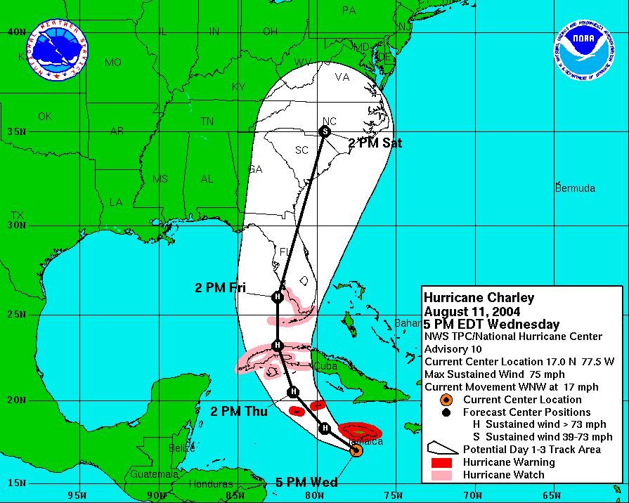
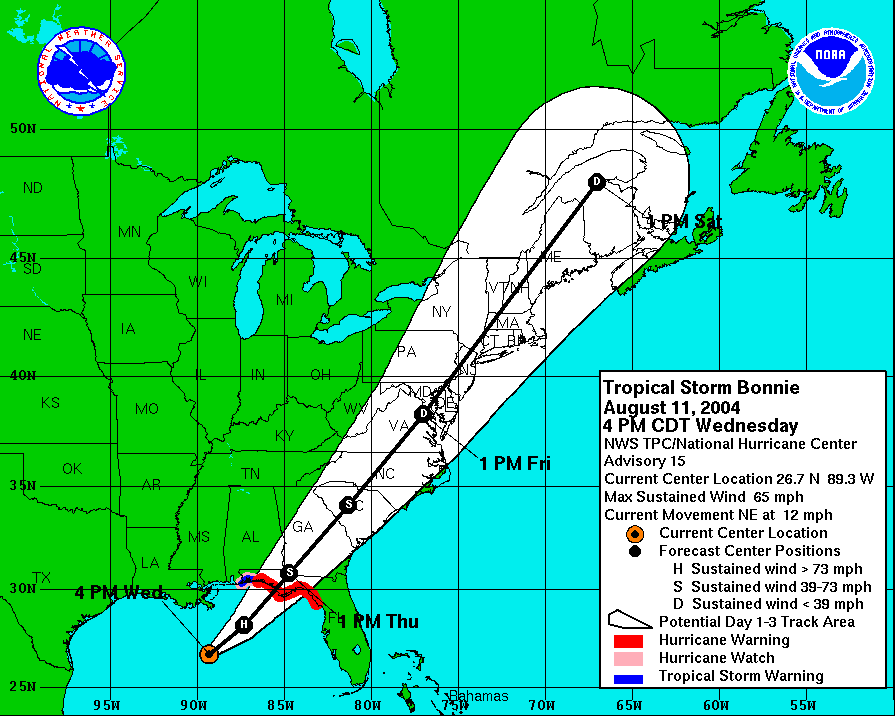
The counties in this area are not currently under an explicit warning from the National Weather Service, though Governor Bush today issued an Executive Order (04-182) declaring a state of emergency and activating the State Emergency Response Team (SERT) in preparation for the pending dual landfall.
It should prove to be a wet, if not interesting week!
Addendum: This article will continue to be edited and updated directly throughout the storm with the latest entries appearing at the top.
I piss upon the hurricanes. They knew I was going to the beach this week.
Are you still going to the beach?
I was supposed to fly to Orlando on Friday and land about the time that Charley was to be over Central Florida.
Hopefully, I'll be able to move my flight up a day, but nothing is certain.
Good Luck!
Muhahahahahahaha
http://news.bbc.co.uk/1/hi/world/americas/3557180.stm
Millions have been put on alert as a hurricane and tropical storm sweep across the Caribbean and head towards the US state of Florida.
Hurricane Charley battered the Cayman Islands on Thursday as it headed towards Cuba and Florida.
One man was reported killed in Jamaica on Wednesday night as heavy rains caused floods on the south coast.
Tropical storm Bonnie was forecast to hit Florida on Thursday, with hurricane Charley expected to hit hours later.
In western Cuba, the authorities have evacuated 25,000 people from low-lying areas, where there are fears of flooding. Tourists have been taken off a southern resort island.
Hurricane Charley is expected to hit Cuba by nightfall and pass almost directly over the capital Havana, before reaching Florida early on Friday.
A hurricane warning has been issued for the Florida Keys and for the south-west Florida coast.
The state faces as double threat as tropical storm Bonnie is heading towards the western coast.
Governor Jeb Bush has declared a state of emergency and put 8,000 National Guard troops on alert as the twin storms approach. Schools and government offices have closed.
Bonnie, currently in the Gulf of Mexico, has forced the evacuation of more than 100 oil rigs and has triggered heavy rains in Florida.
Oil production disrupted
Hurricane Charley has winds of about 85 mph (137 km/h), which are expected to strengthen.
Although it did not hit Jamaica directly, rains from the hurricane caused mudslides and flooding in parts of the island. The main airport has been closed and some cruises have been diverted.
Authorities in the Cayman Islands told people to stay indoors on Thursday as wind and rain battered the islands.
The Caymans are a wealthier and better-prepared British dependency and some tourists there were taking the alert in their stride, the Associated Press news agency reports.
"I've never been in a hurricane before," a US visitor from Las Vegas told the agency. "I'm kind of excited."
Bonnie weakened overnight but regained some strength early on Thursday.
It has already caused widespread disruption to oil and gas operations in the Gulf of Mexico.
Gulf oil production has been cut by 25% and natural gas by 17%, according to the US Minerals Management Service.
The management here at work asked me to send out regular storm update e-mails to the company. I thought I would post them here as well.
12 August 2004, 1243
Clarice asked me to pass long some updated information on Hurricane Charley. For up to the minute updates, visit the National Weather Service storm information page: http://www.nhc.noaa.gov/
Orange, Seminole, Osceola, Lake, Volusia counties are under no specific watches or warnings at this time, but this is expected to change in the next twelve to twenty-four hours. Watch and Warning information is updated by county at this site: http://weather.gov/alerts/fl.html
At 1100 EDT, Hurricane Charley was increasing in strength. It was moving to the northwest at 17 MPH with predictions indicating a turn to the north-northwest later today.
Maximum sustained winds are at 90 MPH, making Charley a strong Category One storm on the Saffir-Simpson scale. Once Charley has passed over Cuba, predictions indicate the storm will intensify as it travels toward Florida due to the high water temperatures in the Gulf of Mexico (around 85F). If the storms winds are sustained at 96 to 110 MPH, it will be a Category Two.
Hurricane force winds extend upward to 25 miles from the center of the storm while tropical storm force winds extend upward to 115 miles from the center.
The National Weather Service will release an intermediate advisory at 02:00 PM today and a full advisory at 05:00 PM today.
Area schools have indicated they will close tomorrow. For a complete listing of known closures, visit:
http://b.www.orlandoweather.com/hurricanes/3647350/detail.html
Please let me know if you have any questions and I will do my best to answer.
12 August 2004, 1411
As of 02:00 PM, Hurricane Charley has intensified into a Category Two storm with maximum sustained winds of 105 MPH and higher gusts. New forecast models indicate Charley may intensify into a Category Three storm before it makes landfall over Cuba tonight.
Landfall in the Florida Keys is expected around 08:00 AM tomorrow morning.
Central Florida is currently under a Tornado Watch until 09:00 PM tonight. Further area Watches and Warnings are expected to be in place by 12:00 PM tomorrow as Charley approaches.
An evacuation order has been issued for coastal and low-lying areas of Pinellas County. 350,000 people are currently affected by this evacuation order. The order will stand until the storm's maximum sustained winds drop to 40 MPH or lower.
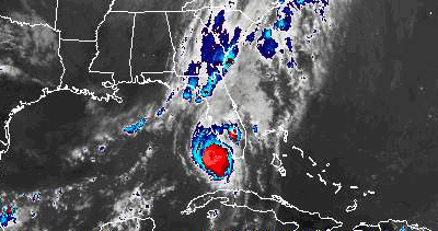
To look at a RADAR image of Florida and Cuba showing Charley's approach, visit this page: http://weather.gov/radar/latest/DS.p38cr/si.kbyx.shtml
I was to start my new job tomorrow... but they called and said because of the weather that it wouldnt be untill monday... so im not braving the storm tomorrow morning like i thought...
David: You betcha
It looks like it'll pass through the jacksonville area around 2AM on Saturday... I don't leave for the beach until around noon... so it'll be gone by the time I arrive.
We were told we may leave work early tomorrow if things get bad. It is appearing less and less now that it will be necessary to do that.
Matt: What beach are you going to visit? Not a JAX beach, I hope.
http://www.local6.com/news/3646424/detail.html
The Kennedy Space Center and Patrick Air Force Base facilities in Central Florida are operating under "Hurcon 3" alert level Thursday, according to Local 6 News.
Wednesday, space officials and workers at Kennedy Space Center picked up loose items that could get blown around in the event of strong winds in the county. They are bracing for winds in excess of 60 mph, Local 6 News reported.
No shuttles are outside because they are being upgraded in the orbital processing facility for possible launch early next year, according to Local 6 News.
Officials at Patrick Air Force Base also tied down sensitive equipment and systems early Thursday.
The Air Force has an Atlas 2 rocket on the launch pad. Officials could cover the rocket with a rotating structure but it will not be rolled back, Local 6 News reported.
http://news.bbc.co.uk/2/hi/americas/3557180.stm
Hurricane Charley has passed through Cuba after gathering strength in the Caribbean and is heading north towards the American state of Florida.
The Cuban authorities say that it caused widespread damage to properties, but reported no fatalities.
The eye of the storm, with winds of up to 165km/h (102mph), passed within 25km (15 miles) of the capital, Havana.
Nearly one million people on Florida's south-west coast have been urged to leave their homes.
State of emergency
About 200,000 people had been evacuated from parts of western Cuba, and tourists have been airlifted from the most vulnerable areas ahead of the storm's arrival.
Hurricane Charley hit Cuba near the port of Batabano, 40km (26 miles) south of Havana at about midnight (0400 GMT).
"The winds are incredibly strong, but there is little rain," a local official told Reuters news agency.
The hurricane took almost three hours to cross Cuba.
It left behind a broad trail of damaged homes and extensive flooding.
There had been fears that Havana would be badly hit.
The BBC's Stephen Gibbs in the capital said civil defence groups were warning people in the city's many fragile and exposed buildings to prepare to spend the night in shelters.
The hurricane did pass extremely close, but initial impressions suggest that damage is slight.
During the storm's most dangerous hours, all Cubans were instructed to stay indoors.
The streets of the capital were deserted, and the electricity supply was cut.
Flash flooding
The hurricane is expected to gain strength as it travels north through the Gulf of Mexico.
Florida - also hit by a tropical storm - has declared a state of emergency.
Schools and government offices have closed.
"This has the potential of being the one we've all been warning about," Governor Jeb Bush said.
"It's going to cut a swathe through the state that's going to impact millions of people," he added.
Meteorologists say the storm is likely to make landfall near the cities of St. Petersburg and Tampa later in the day.
Rainfall of up to 20cm (eight inches) and flash flooding are likely. Charley could also generate tornadoes.
Scientists also say Charley, which is currently categorised as one level below a major hurricane, could soon be upgraded to the highest level.
Officials in Florida's St Petersburg-Clearwater area have told 350,000 people to leave beach areas and mobile home parks.
In the Florida Keys area, tourists and residents were being evacuated from mobile homes.
Residents along Florida's south-western coast have been boarding up their homes and stocking up on water, tinned food and batteries.
David: Yes, in fact. Amelia Island.
Current projections show that it'll be in Georgia by 8AM, looks like it'll be passing over Amelia Island around 2AM. I don't even leave tally until midday tomorrow so I won't even see the storm.
Hope all goes well in Orlando... that's a big storm.
Well all is well here... we regained power at about 2:30 maybe 3:00 and it was most welcome!
after that we regained phone lines so at least im able to dial up(YUCK) and check my email....
there are downed tree limbs everywhere, there is at the moment, a big ol tree limb on my screen(for my screened in pool) punctureing the screen and laying on the cross beams. and there are many holes in the screen now...
our solar panels that heat our pool are destroyed... there is no saving them they are definatly going to have to be replaced but oh well thats what home owners insurance is for... not that i know anything about home owners ins....
we had an old satellite dish that we no longer use and it came off the pole it was attached to. Luckily it didnt puncture any part of the house. it just made a hole in the screen and laid ontop of the awning that connects the house to the screen and that(the awning) wasnt even damaged by the dish falling on it.
our cars are ok.. there is a dent in my mom's van but its not very big. all the windows are intact on both cars and my car only suffered a few scratches. all in all we came out relatively unscathed...
i really didnt sleep well last night. without power i didnt have my celing fan. it wasnt because the fan wasn't circulating wind, it was the small white noise that it generates that helps me sleep. also my window was open and generally im not into that but it was very necessary that i had it open. but someone had a generator and i heard that and then crickets and frogs and even cars passing by kept me awake. needless to say it was a bad night's sleep. i look forward to crashing tonight.
well i think thats all i have to report for now. I hope everyone else is well.
http://www.local6.com/weather/3653987/detail.html
PUNTA GORDA, Fla. -- Rescuers rummaged through a chaotic landscape of pulverized homes and twisted metal Saturday, racing to tally Hurricane Charley's "significant loss of life" and help thousands left homeless by its vicious winds and rain. At least 15 people were confirmed dead.
As a weakened Charley churned into the Carolinas and was downgraded to a tropical storm, newly sunny skies revealed its destruction in Florida, where emergency officials pronounced it the worst to wallop the state since Hurricane Andrew tore through in 1992. Twenty-six deaths were directly linked to Andrew, which caused $19.9 billion in damage.
"Our worst fears have come true," said Gov. Jeb Bush, who surveyed the devastation by helicopter. The Category 4 storm was expected to cost Florida "at least several billion dollars," said Loretta Worters, spokeswoman for the Insurance Information Institute.
Ten deaths had been confirmed in Charlotte County, said Wayne Sallade, the county's director of emergency management, but no exact death toll was available. "It's Andrew all over again," Sallade said.
"We believe there's significant loss of life, he said, adding later: "I would hope that it would be limited to dozens, if that."
He said "thousands upon thousands of people" lost their homes. Hundreds were unaccounted for in the county, which includes Punta Gorda and Port Charlotte, the apparent hardest-hit areas. Extensive damage was also reported on exclusive Captiva Island, a narrow strip of sand west of Fort Myers.
Thirty-one mobile-home parks in Charlotte County sustained major damage, some with more than 1,000 units, said Bob Carpenter, a sheriff's spokesman. He said teams were sent to each park to search for bodies and survivors, but "we just couldn't get the vehicles in - there is so much debris."
Several medical centers were badly damaged, forcing hospital officials to evacuate patients to other facilities.
"Where do we go now? What do we do?" said 69-year-old Barbara Seaman, standing by the shell of a demolished building in Punta Gorda's Windmill Village Trailer Park.
The storm and its 145-mph winds knocked out power to some 2 million homes and businesses as it crossed from the southwest coast at Punta Gorda to the Atlantic at Daytona Beach. Some 1.3 million remained without power Saturday afternoon, emergency officials said, and downed lines slowed some rescuers.
Three cities in southwest Florida -- Arcadia, Port Charlotte and Punta Gorda -- were without running water, state environmental officials said.
President Bush, the governor's brother, declared Florida a federal disaster area. The president planned a visit Sunday to survey damage, and Democratic presidential candidate John Kerry, in a statement, offered "heartfelt sympathies."
The hurricane rapidly gained strength in the Gulf of Mexico after crossing Cuba and swinging around the Florida Keys as a more moderate Category 2 storm Friday morning. An estimated 1.4 million people evacuated in anticipation.
When it hit, the storm upended trucks, twisted traffic lights and lifted entire houses atop neighbors' homes.
Entire trailer parks were torn to splinters, and dazed residents wandered around neighborhoods, gathering miscellaneous belongings. At the Port Charlotte airport, small planes were stacked and snapped apart like toys cast off by an angry child.
"I've been through typhoons in Guam, and I've never seen anything like this," said Charles Charwat, an 84-year-old retiree in Ormond Beach, on Florida's east coast.
There were five confirmed storm-related deaths elsewhere in the state.
Mike McHargue, director of investigations for the Florida Department of Law Enforcement, said two people died in Polk County, and the others were in DeSoto, Lee and Sarasota counties. He said downed power lines and debris made the work of searching for bodies "tedious and dangerous."
Deputies were standing guard over some bodies because they were in areas not immediately accessible by ambulances. Earlier, Charley killed four people in Cuba and one in Jamaica.
As recovery efforts began, Florida officials warned against price gouging and said violators would face heavy fines.
The state's emergency response team was deploying more than 1.8 million gallons of bottled water and 2.9 million pounds of ice to damaged areas.
Deputy State Health Officer Bonnie Sorensen said three medical disaster teams, with 35 to 50 health care workers, were in place and another five would arrive to help those in need.
Thousands of tourists on late-summer vacations were caught in the storm's messy aftermath. More than 1,000 people spent the night at Orlando International Airport, where debris littered two runways and lashing winds tore the roofs off three terminals and shattered two giant glass panels in the main terminal. Scores of flights were canceled.
Hundreds of miles north, Charley's course took it across open ocean, missing the westward curving shore of Georgia. It made its second landfall on South Carolina's Grand Strand resort region, which was nearly empty after a mandatory evacuation of some of the area's 180,000 tourists and residents.
National Guard troops were on duty Saturday in North Carolina, where a mandatory evacuation order was in effect for vulnerable coastal areas hit less than two weeks ago by Hurricane Alex.
In Virginia, Gov. Mark R. Warner declared a state of emergency. Charley-related weather was forecast as far north as Massachusetts, the New York metropolitan area and swaths of northern Pennsylvania. All of New Jersey was under a flood watch Saturday afternoon.
The American Red Cross set up more than 250 disaster relief shelters in Florida and 40 shelters in the Carolinas. Staffers and volunteers were providing dry clothing, meals, first aid and counseling.
In Orlando, central Florida's major theme parks reopened Saturday. At Walt Disney World, the Magic Kingdom, Epcot and Disney-MGM Studios opened, but staff shortages kept Animal Kingdom closed. Fifty inspectors at Universal Studios Orlando checked all the rides and ruled them safe.
As people unbattened their hatches and emerged into the sunlight, the stories of nature's fury flowed.
In hard-hit Hardee County southeast of Tampa, Albert Whiteras, 56, said he had no idea the storm was coming until his daughter saw on the television news that it had changed direction.
"When you look at trees snapping in half in your backyard -- Oh, my Lord, it was the most frightening thing I've ever seen in my life," he said. "I've been through these before. I know what they can do, but I didn't think it would do it."
Dan Strong, 51, picked through broken furniture, a tipped-over stove and soaking wet sofas as he surveyed damage at his mobile-home park in Punta Gorda.
"What I really need is a big broom," Strong said.
Three hospitals in the county sustained significant damage, Sallade said. Officials at Charlotte Regional Medical Center in Punta Gorda said they were evacuating all patients Saturday.
"This place just isn't safe," said Peggy Greene, chief nursing officer. She said windows were blown out, part of the roof was blown off, and there was no power or phone service.
Among those seeking treatment was Marty Rietveld, showered with broken glass when the sliding glass door at his home was smashed by a neighbor's roof that blew off. Rietveld broke his leg, and his future son-in-law suffered a punctured leg artery.
"We are moving," said Rietveld's daughter, Stephanie Rioux. "We are going out of state."[/bq]
Bush to witness hurricane damage
[original article]
[bq]President George W Bush is to travel to Florida where a hurricane has killed 13 people and caused damage estimated to cost billions of dollars.
Emergency staff say the toll may rise as hundreds of people remain unaccounted for after the strongest hurricane to hit Florida in 12 years.
The president's brother, Florida state Governor Jeb Bush, said whole communities had been flattened. The hurricane has also hit North and South Carolina but in a weaker form.
About 200,000 people in the Carolinas lost their electricity supply and there were a few reports of flooding and wind damage.
'Freak hurricane'
In Florida, people are attempting to salvage their possessions.
The worst-hit communities appear to be Punta Gorda and Port Charlotte in Charlotte County.
"Our worst fears have come true," said Jeb Bush, who flew over Punta Gorda by helicopter.
Packing winds of up to 145mph (230km/h), Charley came ashore on Friday at 1550 (1950 GMT) at Punta Gorda, catching many residents unprepared because it was believed the storm would hit further north.
"This type of hurricane only happens once every 100 years, they say," Harry Thomas told Reuters as he looked at his destroyed motel in Port Charlotte.
The hurricane ploughed across central Florida, uprooting trees and power lines, and dumping heavy rains.
More than one million people have been left without electricity and hundreds of thousands without water.
Heather Stone from Cape Coral said she and her family taken refuge under a mattress in a bathroom:
"There's a hospital about 100 yards from our house, and in the maternity ward the roof blew off while a woman was in labour."
Anne Correia, who hid in a wardrobe in her flat in Punta Gorda, said she could "hear the nails coming out of the roof".
"The walls were shaking violently, back and forth, back and forth," she said.
Worst since Andrew
President Bush has declared the region a disaster area, which means federal funds can be spent on the clean-up.
Before reaching land in Florida, the hurricane increased to category four - the second most severe on the five-level Saffir-Simpson hurricane intensity scale.
Florida officials say Charley is the worst storm to hit their state since 1992 when Hurricane Andrew caused billions of dollars worth of damage in Miami.
At least three people died when the hurricane passed over western Cuba on Friday.
In a rare gesture, the US offered Cuba $50,000 (about ?28,000) to help pay for damage caused by the hurricane.
Charley was also blamed for one death in Jamaica on Thursday.
I'm back and I didn't die. So that's good.
The power is back on...yay!! Sweating is shitty...for the record! And my internet it back up so we are finally able to communicate with the world... I never thought I would miss the internet this much.... yay for AC!!! (sorry it JUST came back on so I am still euphoric)
Great to hear from both of you!